Posts

Showing posts with the label 1960s

First Land Reclamation Project by HDB

Image
Some of the land areas of Singapore were reclaimed from the rivers and the seas to create new land in order to support a growing population in the early days. This is known as land reclamation. The HDB also carried out reclamation projects to build flats so that Singaporeans can have a roof over their heads. The earliest reclamation project was focused on Kallang Basin. Before the reclamation in the early 1960s, Kallang Basin used to be surrounded by squatter huts where residents lived in unsanitary conditions. Kallang Basin in the midst of reclamation, 1964 Squatter huts in Kallang Basin before land reclamation, 1964 Over the next decade until the mid-1970s, approximately 1000 acres of land have been reclaimed at Kallang Basin to build not only new flats in 3 neighbourhoods but also industrial development like flatted factories and terrace factories so that residents who were rehoused into these new flats could look for employment opportunities easily. An aerial view of B...
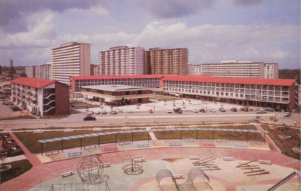
Toa Payoh in the 1960s

Image
During the 2nd Five-Year Plan between 1965 and 1970, about 95,000 of Singapore's population moved into the new flats at Toa Payoh with a total of around 18,000 units. It is the first HDB Estate to introduce the Improved flats for 3 room units where each flat has an extension of the kitchen and balcony together with a separate bathroom and toilet. Such flats in those days cost $7500. New 16-storey flats at Lorong 3 and low-rise flats with a wet market at Lorong 4 Toa Payoh, 1967 2-room flats at Blk 120 Lorong 2 Toa Payoh, 1967 The newly constructed Food Centre at Lorong 5 Toa Payoh, 1967 10-storey flats at Toa Payoh Rise, 1968 One of the tallest flats in Lorong 2 Toa Payoh, 1968 New flats at Lorong 1 Toa Payoh in the vicinity of Braddell MRT station, 1968 An aerial view of Lorong 1 Toa Payoh from Kampong San Theng, 1968 Newly built 5 Food Centres near Blk 127 Market in Lorong 1 Toa Payoh, 1969 The iconic dragon statue in front of Block 91, 1969 New...

A mixture of old SIT flats and new HDB flats

Image
Before HDB was formed, many 3 and 4-storey walk-up flats together with some single-storey artisan quarters built by the Singapore Improvement Trust (SIT) were found in estates like Tiong Bahru and Bukit Merah. However, as some of these flats were located on low ground and were periodically affected by occasional floods, it has been decided that the artisan quarters in Bukit Merah were to be demolished to make way for high-rise flats for safety purposes. 1-room emergency flats in Redhill, 1965 New 16-storey flats at Lengkok Bahru, 1966  An aerial view of Hoy Fatt Road, Lengkok Bahru and Jalan Rumah Tinggi flats, 1966 Jalan Bukit Merah new flats in Tiong Bahru, 1967 An aerial view of Jalan Bukit Merah in Tiong Bahru, 1967 The newly completed Market and Food Centre at Blk 112 Jalan Bukit Merah, 1968 The first 4-room flats built at Henderson Crescent, 1967 10-storey new flats at Redhill Road, 1968 1-room Improved flats at Redhill Road, 1968

A new Bukit Ho Swee

Image
In 1961 before the disastrous fire at Bukit Ho Swee, this area used to be one of the worst attap slums in Singapore with unsanitary and unhygienic conditions. By the time Singapore gained independence in 1965, it has transformed into a modern housing estate with a maternity and child health clinic, markets, playgrounds and schools in the area together with 11,000 units being built with approximately 70,000 people living in these flats. 16-storey flats at Havelock Road Beo Crescent flats, 1965 Bukit Ho Swee Secondary School, 1965 A children's playground